
Your Community Builder
Your Community Builder
A celebration of an uncommon landscape
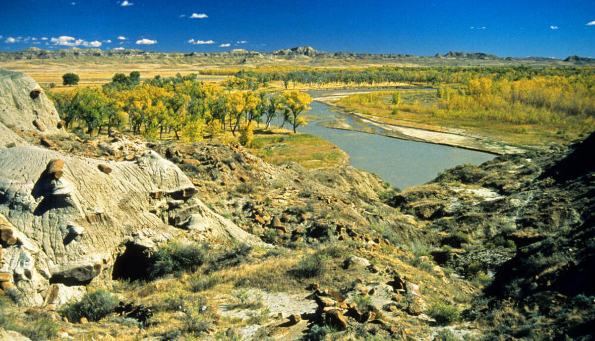
Powder River, near Miles City
CONTINUED FROM
LAST WEEK
Plenty of space, minimal human activity and protected lands ensure thriving wildlife and waterfowl population.
Together, Medicine Lake National Wildlife Refuge, tucked in Montana's northeast corner and Bowdoin National Wildlife Refuge out of Malta make a home for more than 200,000 ducks and geese, as well as lake pelicans. Other havens, such as Half-Breed National Wildlife Refuge at Rapelje, Freezeout Lake near Choteau and War Horse Lake National Wildlife Refuge northwest of Winnett, also attract migratory congregations.
Then there is one of America's extraordinary places - the wild, remote and beautiful Charles M. Russell National Wildlife Refuge includes 1,100,000 acres in a 200-mile strip encircling Fort Peck Lake. Its deep canyons, rough river breaks and isolation provide a sanctuary for wildlife, big and small. It includes the UL Bend Wilderness, home ground for native elk and transplanted bighorn sheep.
In these parts, history is recent and evident. The old West of legend spanning a short yet wild time was played out here. Only 150 years ago, indigenous hunters sought the enormous bison herds that thundered across Montana territory. They had the plains to themselves, wandering freely in search of food and shelter. Then the 1804-1806 Lewis and Clark Expedition changed the face of the land and the native culture forever. This Corps of Discovery marked the way for the white invaders.
At first, the newcomers-mountain men, trappers, traders and explorers - came in search of beaver pelts and routes west. Soon steamboats began plying the Missouri to Fort Benton. The first one reached Fort McKenzie, just below Fort Benton, in 1859. Gold seekers followed, combing the gulches of the Judith Mountains and Little Rockies. More people entered Indian lands.
Grass was rich, thick and free for the taking. Central and eastern Montana had what seemed an endless supply. By the 1870s, western Montana stockmen ventured into the lush river bottoms and the tall grass to the east, laying claim to the vast open range. They were joined by the legendary drives of longhorns, up 1,800 miles from Texas to winter in Montana.
The era of the big ranches had begun. The Circle C and DHS ranches located in the country between Malta and Lewistown became symbols of Montana. These times bred rustlers, horse thieves, cattle barons and vigilantes. The myths and reality of the American cowboy took root. Outlaws met with frontier justice handed out by "Stuart's Stranglers," named for prominent rancher Granville Stuart. During this time, the Natives took their last stand and lost. The bison were gone and the white man was too powerful. A culture and way of life all but disappeared from eastern Montana.
The cattlemen were soon to have their freedom curtailed as well. The tough winter of 1886-87 caused heavy livestock losses and began the decline of the large operations.
During the 1880s, railroads were pushing their way into Montana from the Dakotas. The Great Northern, Milwaukee Road and Northern Pacific lines brought farmers to plow the virgin sod and fence the land. The cattle empires, weakened by winter, shrunk further as the open grasslands diminished. Sheep moved in on the cattle and by 1900, outnumbered cows on the prairie. For a while, Montana was the number one wool-producing state in the nation.
At the turn of the century, railroad promotions and the building of towns aside the steel roads, coupled with generous homestead laws (a grant of 320 acres after 1909) brought a wave of people to Montana east of the mountains. They arrived from points across the USA and from Europe to cultivate riches from the soil. Some prospered, but many didn't. The time of the homesteader peaked in 1918. The wet years disappeared and drought and low prices set in. Thousands left their places, never to return. Prairie vegetation gradually reclaimed fields that once produced bountiful harvests.
Remnants and vivid reminders of early day prairie Montana are everywhere. Portions of former travel byways such as the Great North Trail, the Nez Perce Trail, the Wood Mountain Trail, the Whoop-Up Trail and the Pony Express Route are still visible, as are the ruins of forts, trading posts and stagecoach stops. Undisturbed areas show signs of travois tracks, wagon wheel ruts and teepee rings.
Evidence of the era of the first sodbusters is plentiful. Old buildings that once housed these settlers and their dreams still stand, only to serve as refuges for small animals, birds and owls.
Although the drought and economic conditions ended their hopes, some hearty pioneer families persisted, stayed on and today are the backbone of the Montana prairie country.
Descendants of the homesteaders and products of cattle outfits that have been in the same family for generations provide the area with a sense of permanency and independence, a strong profile dictated by rural life and past experiences that characterize this corner of the Great Plains.
It might be facetious to say distance between communities is comfortable and elbowroom is plentiful. Here, space dwarfs the human presence whether it is on farms and ranches well apart from neighbors, or in towns with colorful names ... Sunburst, Judith Gap, Roundup, Cut Bank, Plentywood, Medicine Lake, Redstone, Sand Springs, Whitewater, Whitetail, Flaxville, Choteau, Big Sandy, Chinook, Lame Deer, Lodge Grass, Ekalaka, Grassrange and Wolf Point as well as Billings, Great Falls, Lewistown and Miles City. The latter four, large towns by Montana standards, are but small outposts on the vast Montana plains.
High school basketball teams often have to travel up to 300 miles one-way for games. The population is dispersed enough to support many one-teacher schools consisting of grades one through eight with an average of 15 students. More than 50 of them are still open east of the Rockies.
Towns are the essence of this territory where the natural features capture attention. Social and commercial activities interact within them in a way that is all but disappearing across America. Cafes, hardware and grocery stores are where stockmen, farmers, implement dealers and bankers meet to discuss ag-economics, their families, and the weather. You'll still find drug stores with soda fountains and chances are that you can walk in the door of any business and shake the hand of the owner. A genuine welcoming atmosphere prevails.
To the uninitiated, life in many of these hamlets might seem carefree, but the problems of a lagging agricultural economy, lack of opportunities for the young, and drought are real. The people of these isolated havens that dot the sprawling prairie deal with them and never give up. A "can do" attitude holds sway over town meetings or at the supper table as residents look for answers and new possibilities. Hope always seems to be there.
Livestock operations and dry land farming are the major economic pursuits of Montana east of the mountains, and most of the cultivation involves wheat.
Winter wheat is planted in late summer and gains a foothold before the cold descends. It renews growth with spring's warmth and is harvested in July. Montana's dominant crop, it crowds the horizon of The Golden Triangle ... the country north and northwest of Great Falls. Farther east and north, where winter is colder, spring wheat colors the fields. Seeds are sown at winter's end and the crop is cut in late summer. Yields tend to be lower with this strain of wheat.
Strip farming is a trademark. In heavily cultivated areas, successions of wheat, interspersed with fallow earth, stretch as far as the eye can see. This farming practice serves as a deterrent to wind erosion and conserves moisture. Each year the pattern is reversed.
Sugar beet farming doesn't create the same scenic mosaic as the ribbons of wheat fields do, but in the valley of the Yellowstone River, especially between Laurel and Glendive, it adds to the well-being of southeast Montana.
While the big unfenced ranches of the mid - to late 1800s are gone, cattle are still very important on Montana's high plains. Cowboys continue to work the range and substantial ranches exist in Yellowstone and surrounding counties. Miles City in Custer County is known as the "Cattle Capital of Montana."
Montana's Indians, to a degree, survived the devastation of their homelands and are a prominent part of this piece of the Big Sky Country. They are the Blackfeet, the Chippewa, the Cree, the Crow, the Northern Cheyenne, the Assiniboine, the Gros Ventre and the Sioux nations. Some still occupy a portion of their ancestral grounds, others do not. Most live on six reservations scattered throughout the Northern Plains. Powwows, rodeos, Milk River Indian Days, North American Indian Days and the Crow Fair are tributes to their proud tribal traditions.
As the first residents of Montana, these natives were good stewards of the land. They respected it and took only what they needed to survive. They passed through and left it as they found it. Their legacy is still present out here in the places that have remained unaltered with the passing of the ages, and their spirit is still carried on the wind. Listen for it and feel it as you explore and marvel at Montana east of the mountains.
Rick Graetz is a professor in the University of Montana's Honors College and director of UM's This is Montana program and other UM initiatives. Susie Graetz is a Senior Fellow in the the university's O'Connor Center for the Rocky Mountain West.


Reader Comments(0)