
Your Community Builder
Your Community Builder
Sorted by date Results 1 - 18 of 18
A historical sign on the edge of town states Ekalaka was established in 1885 by a bison hunter who set out to erect an "edifice for the eradication of ennui." His wagon became stuck in the snow, and that's the point where he started the underpinnings of a community. His explanation was "Hell, any place in Montana is a good place for a saloon." He unloaded the lumber he had in the wagon and commenced construction on the spot. However, the town wasn't named after this initial...
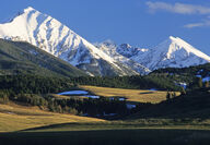
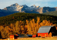
For the most part, the physical and social geography of Southwest Montana has changed little with the passage of time. Ranching and agriculture are the major lifestyles, and the Bitterroot and Gallatin valleys still draw the most folks. Water, which played a significant role in the past, is still important today. Here in this quadrant of the state is the gathering place for the rivers forming the three forks of the big Missouri. The Jefferson and Gallatin both get their start...
Fur trappers, followed quickly on the heels of Lewis and Clark into the new frontier. Searching for beaver to satisfy the latest fashion demands of Europeans, they wandered to what would become Montana Territory and particularly to the southwest sector of the state. But they were not settlers, just passers-through, and they left behind a mostly negative legacy that included degradation of the natives and a depletion of resources that saw the profits flow to only a few....
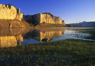
An important portion of The Corps of Discovery's journey occurred in southwest Montana. On July 19, 1805, Lewis and his men were struggling up the Missouri between present-day Upper and Lower Holter lakes. "from the singular appearance of this place I called it the gates of the rocky mountains." The next day, searching for "the three forks of the Missouri," they entered the first of southwest Montana's big valleys – Helena's Prickly Pear Valley. Arriving at the meeting of t...
Defining a province like Southwest Montana is subjective. For us, an imaginary line commences at Lolo Pass west of Missoula and moves east along Interstate 90 and the Clark Fork River to Garrison Junction. Then it follows Highway 12 over McDonald Pass to Helena. From there, our boundary extends slightly in a southeasterly direction, taking in the Big Belt Mountains before heading to Bozeman and then along the Gallatin Range crest to West Yellowstone. The south and west line of...
In September 1887, the railroad arrived at Fort Benton, signaling the end of the era of river trade, and it seemed the town would die. But a Canadian trade boom opened, resulting in the establishment of the 240-mile-long Whoop Up Trail pointing north to Fort Macleod, Alberta. Although plenty of legitimate commerce was carried out, the trail became known for the illegal whiskey transported on this dangerous and adventure-filled route. Fort Benton is one of the most fascinating...
Fort Benton rests along the mighty Missouri River. Founded in 1846, it's the oldest town in Montana. During its first century, Fort Benton would become a springboard for trade as goods would be offloaded at the navigable end of the Missouri River and transported west by wagon. Flood control and other initiatives in the 1940s rendered Sioux City the new head of navigation on the Missouri, as the Great Northern railroad would become the primary means of transportation to the...
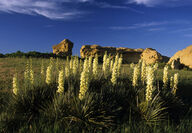
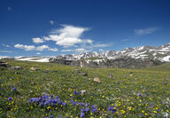
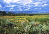
Two particular flowering plants are the toast of late spring and summer in Montana. In the mountain forests and openings of northwestern Montana, beargrass – the official flower of Glacier National Park – struts its stuff along roads and highways, as well as throughout the wilderness areas in northwest Montana. Meanwhile, the sturdy yucca stands guard over the rolling land and river breaks east of the mountains. Both plants, so similar yet so different, are symbolic of the...
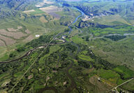
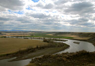
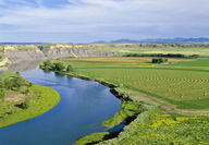
A labyrinth of channels, willow bottoms, islands and a general mix of wetlands interact to piece together the headwaters of the Missouri River. The point where the three forks – the Jefferson, Gallatin and Madison rivers – join as one, the great Missouri River begins an odyssey, heading out as having had the starring role in the creation of a state. As a route of western expansion, the Missouri River had few equals. Missouri Headwaters State Park, at the three forks, doc...
"... by every rule of nomenclature, the Missouri being the main stream and the upper Mississippi the tributary, the name of the former should have been given precedence, and the great-river should have been called Missouri from the Rocky Mountains to the Gulf of Mexico." Many people, especially Montanans, agree with this unknown author's statement. However, the Mississippi was explored first and thus designated the primary stem, leaving the Missouri to receive tributary...
On June 16, 1805, Captain Clark of the Corps of Discovery – with an extremely ill Sacajawea accompanying him – halted below the confluence of Belt Creek and the Missouri River ("portage creek," to the Corps), setting up what would become the base camp for their month-long assault around the "great falls." As part of Meriwether Lewis's effort to cure the young mother, he used the water of a sulphur spring that is located across the Missouri from the mouth of Belt Creek and cal...
When the Missouri River puts Cascade behind, it looks out toward the sunset and the distant Rocky Mountain Front, the range of mountains that gave Montana its label "Land of the Shining Mountains." On July 18, Lewis wrote, "We passed the entrance a beautifull river 80 yards wide which falls in a Lard (left side). Which in honour of Mr. Roberts Smith secretary of the navy we called Smiths River. This stream meanders through a most lovely valey to the S.E. for about 25 miles...
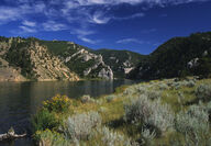
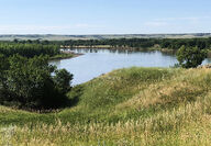
Almost immediately upon departing the Three Forks area, the newly formed Missouri is neatly tucked into a mini-gorge. Then, only 16 miles from its inception, the Toston Reservoir and Dam decelerate its flow. After traversing the "Little Gates of the Mountains," so noted on Clark's map of July 25, 1805, as "2d range of mts - little gate," near the small village of Toston, the river will soon ply the last of the big southwest valleys. Officially established when the post office...

On Aug. 12, 1805, Meriwether Lewis penned in his journals, "the road was still plain, I therefore did not dispare of shortly finding a passage over the mountains and of tasting the waters of the great Columbia this evening. At the distance of four miles further the road took us to the most distant fountain of the waters of the mighty Missouri in search of which we have spent so many toilsome days in wristless nights." Lewis was describing today's Distant Fountain Spring, part...
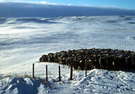
Snow had been falling almost continuously for a week, and it was very cold. The temperature had only risen to minus 18 degrees. Finally, late in the day, the snow and wind stopped, skies cleared rapidly, and as the sun set the temperature plummeted. Early the next morning, on Jan. 20, 1954, the Montana and continental 48 states' record cold temperature of minus 70 degrees was observed at a mining camp near the Continental Divide a short distance from Rogers Pass near Helena....
From a cluster of old buildings just off Interstate 15 at Monida Pass, a dirt road winds its way through dry, windswept hills before easing down into southwest Montana's high and remote Centennial Valley. If it weren't for one of the gems of the National Wildlife Refuge system – Red Rock Lakes National Wildlife Refuge – very few travelers would make their way through this nearly 40-mile-long valley. Cattlemen first ventured into the place in 1876, establishing what are now...
Department of Geography Though its length is short in comparison to other major Montana rivers, the landscape the Bitterroot River flows through is long in beauty and historical significance. Guarding it on the west is the abruptly rising Bitterroot Range, while the lower-profiled, forest-covered Sapphires Mountains look down from the east. The surrounding valley is one of the fastest growing regions in the state. The west and east forks of the Bitterroot, rushing out of...

During the Dec. 21 winter solstice, the sun takes a brief respite on the Tropic of Capricorn at 23.5 degrees south latitude. Over the next six months, it journeys north for a June 21 rendezvous with the Tropic of Cancer at 23.5 degrees north latitude. En route, on about March 20, for one brief moment it touches its rays directly over the equator, declaring the spring equinox. In Montana, this pronouncement is merely a promise of something to come, as March's third week...